Route 218- West Point to Cornwall on Hudson
If Route 66 can have its own song, we think Route 218 should have its own web page. Commercials have been shot on it. Movies too. To find a similar locale, one would have to travel to Germany's Rhine River. So you can buckle up and cancel that trip to
 Deutschland.The stretch of Route 218 that always has visitors agog starts just north of the
Lee Gate at West Point. The road hangs aloft, midway up the side of the
cliff wall. The river is always visible to the right but the driver
shouldn't look at it. The road is narrow, curvy and still open to truck
traffic---which can appear quite rapidly in the oncoming lane. As you start to approach Storm King you see the road bed
which was hacked into the side of the mountain early in the 20th Century.You can rest assured that no one in the United States will build such a road
again in your lifetime. Merely proposing a road plan which involved
scarring a massive rock face on protected land would cause pandemonium among
present-day environmentalists. Route 218 stands as a monument to early 20th
Century thinking which maintained that "nature must be tamed and made
useful."
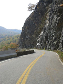
The upshot of it all is that you get to drive on this:During the summer and fall the lookout parking lot
at the highest point of Route 218 on Storm King is usually full owing to the
fact that there is really only space for three cars. If you can't get in
there to park you can drive about another mile into Cornwall on Hudson and turn
around to try again a little later. It really is worth the wait because
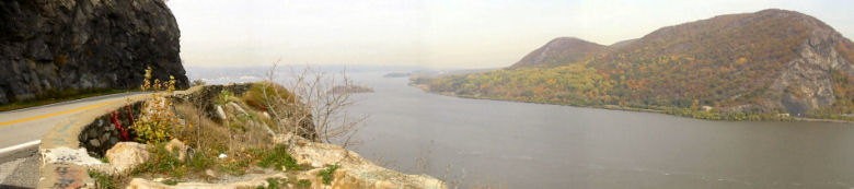
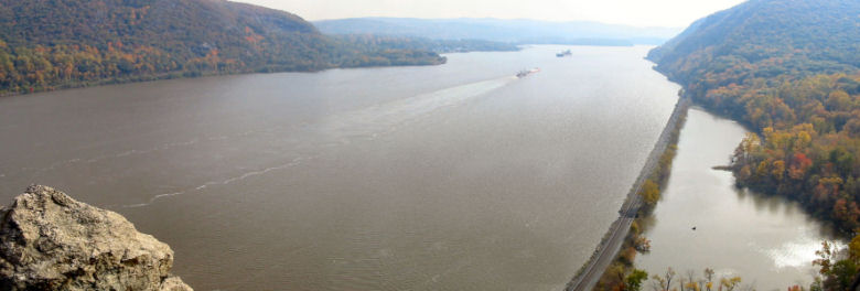
once you get to stop at the lookout you have this vista when
you look up river: and this one when you look down river: Bring a jacket even if the day seems warm. Winds blow
constantly at this precipice.
Deutschland.The stretch of Route 218 that always has visitors agog starts just north of the
Lee Gate at West Point. The road hangs aloft, midway up the side of the
cliff wall. The river is always visible to the right but the driver
shouldn't look at it. The road is narrow, curvy and still open to truck
traffic---which can appear quite rapidly in the oncoming lane. As you start to approach Storm King you see the road bed
which was hacked into the side of the mountain early in the 20th Century.You can rest assured that no one in the United States will build such a road
again in your lifetime. Merely proposing a road plan which involved
scarring a massive rock face on protected land would cause pandemonium among
present-day environmentalists. Route 218 stands as a monument to early 20th
Century thinking which maintained that "nature must be tamed and made
useful."
The upshot of it all is that you get to drive on this:During the summer and fall the lookout parking lot
at the highest point of Route 218 on Storm King is usually full owing to the
fact that there is really only space for three cars. If you can't get in
there to park you can drive about another mile into Cornwall on Hudson and turn
around to try again a little later. It really is worth the wait because
once you get to stop at the lookout you have this vista when
you look up river: and this one when you look down river: Bring a jacket even if the day seems warm. Winds blow
constantly at this precipice.
History of the Storm King Highway A road connecting West Point to
Cornwall had been talked about in the late 1800's, i.e. a road for carts,
carriages and the new vehicles−automobiles. Recall that in those times
the word "road" still meant "railroad", owing to the fact that roads for
other conveyances were few and far between in the USA. By 1905 surveys had been completed and
work was to begin on the Storm King Highway with the hope that this road would
complete the link between New York City and Albany as a section of the old State
Route 3. A route was approved by the state to
tunnel through Storm King Mountain, but the newly-formed Palisades Park
Commission favored 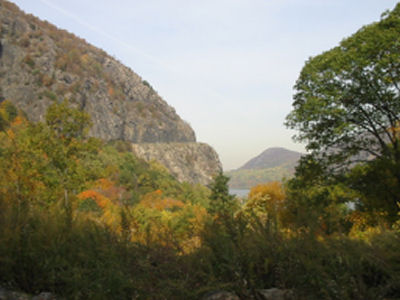 that the road should overhang the side of Storm King
Mountain. Work on the project was stalled for years. The federal
government refused the right of way through West Point and The Storm King Stone
Co., a quarry already existing at the base of the mountain, demanded $250,000
for damages. The job of surveying the mountainside
with conventional surveying equipment was a daunting task indeed. Ships from
the United States Military Academy at West Point steamed up the Hudson and shot
cannon rounds full of red paint at the rock wall to provide surveyor’s marks.
Surveying engineers in many cases hung from ropes as they laid out the
elevations for the Storm King Road. The Cornwall Local in 1915 reported that
an engineer from Fanwood, New Jersey experienced a 220 foot fall after his
“rope parted from him”. He was taken to Newburgh for medical treatment in
a railroad hand-car, and happily,
survived the mishap.After many tribulations the contract
for construction of the road was awarded and by 1916, 75 men worked a 10 hour
shift. But life was not easy for those working on project. The quarry at
the base of the mountain refused the workers access through their property. Machinery
had to be hauled all the way up Mountain Road and then lowered down the mountain
side through thick woods. Cement was carried up the mountain to the work site on
the backs of mules. Blasting with dynamite also presented a problem. In one
instance large chunks of mountain crashed down completely destroying the stone
crusher and some buildings at the base of Storm King. The highway opened in
October of 1922.
that the road should overhang the side of Storm King
Mountain. Work on the project was stalled for years. The federal
government refused the right of way through West Point and The Storm King Stone
Co., a quarry already existing at the base of the mountain, demanded $250,000
for damages. The job of surveying the mountainside
with conventional surveying equipment was a daunting task indeed. Ships from
the United States Military Academy at West Point steamed up the Hudson and shot
cannon rounds full of red paint at the rock wall to provide surveyor’s marks.
Surveying engineers in many cases hung from ropes as they laid out the
elevations for the Storm King Road. The Cornwall Local in 1915 reported that
an engineer from Fanwood, New Jersey experienced a 220 foot fall after his
“rope parted from him”. He was taken to Newburgh for medical treatment in
a railroad hand-car, and happily,
survived the mishap.After many tribulations the contract
for construction of the road was awarded and by 1916, 75 men worked a 10 hour
shift. But life was not easy for those working on project. The quarry at
the base of the mountain refused the workers access through their property. Machinery
had to be hauled all the way up Mountain Road and then lowered down the mountain
side through thick woods. Cement was carried up the mountain to the work site on
the backs of mules. Blasting with dynamite also presented a problem. In one
instance large chunks of mountain crashed down completely destroying the stone
crusher and some buildings at the base of Storm King. The highway opened in
October of 1922.
View from lookout North to Bannerman's Island
View from lookout south to West Point

A Ford Model T makes it's way from Cornwall to West Point on the newly opened Storm King Highway.Source: Post Card Joseph Cornish Cornwall Library Michael Nelson 1996